Mayday! The San Juan snowpack is vanishing

There you have it folks: It was a crappy winter in the Four Corners Country. As of May 1, the San Juan Mountain snowpack, also known as the gargantuan “reservoir” at the headwaters of the region’s major rivers, is just about drained dry. While the snow season is not quite over — a winter storm has settled into the San Juans as I write this — the current numbers almost guarantee that the spring runoff will be meagre and fire season will be rough.

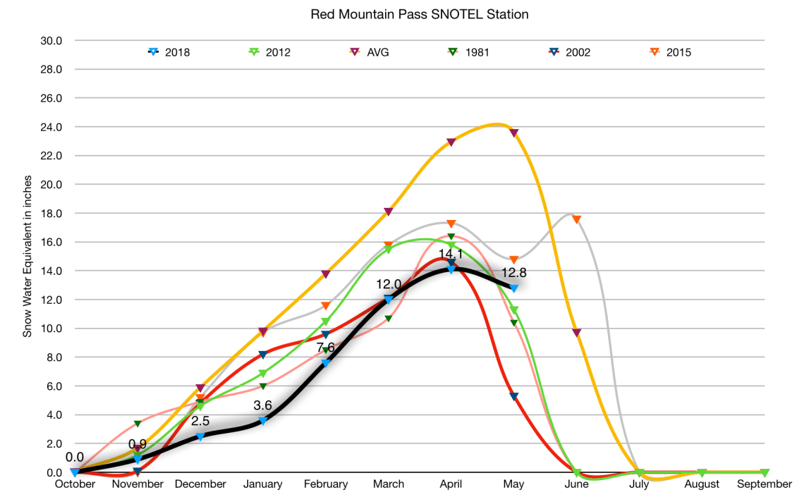
The only bit of good news is that this winter is turning out to be only the second driest over the last three decades — at most monitoring stations, 2002’s numbers were even lower. Also, as one moves northward, the situation tends to improve somewhat. On Red Mountain Pass, for example, the snowpack is currently at about 50 percent of average for this date, and is tracking above levels of 2002, 2012 and 1981.

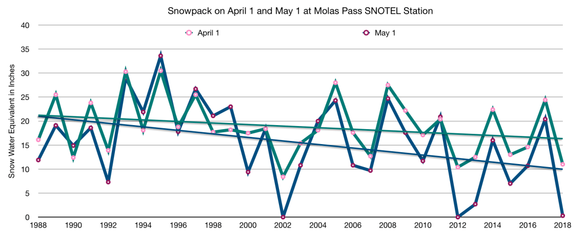
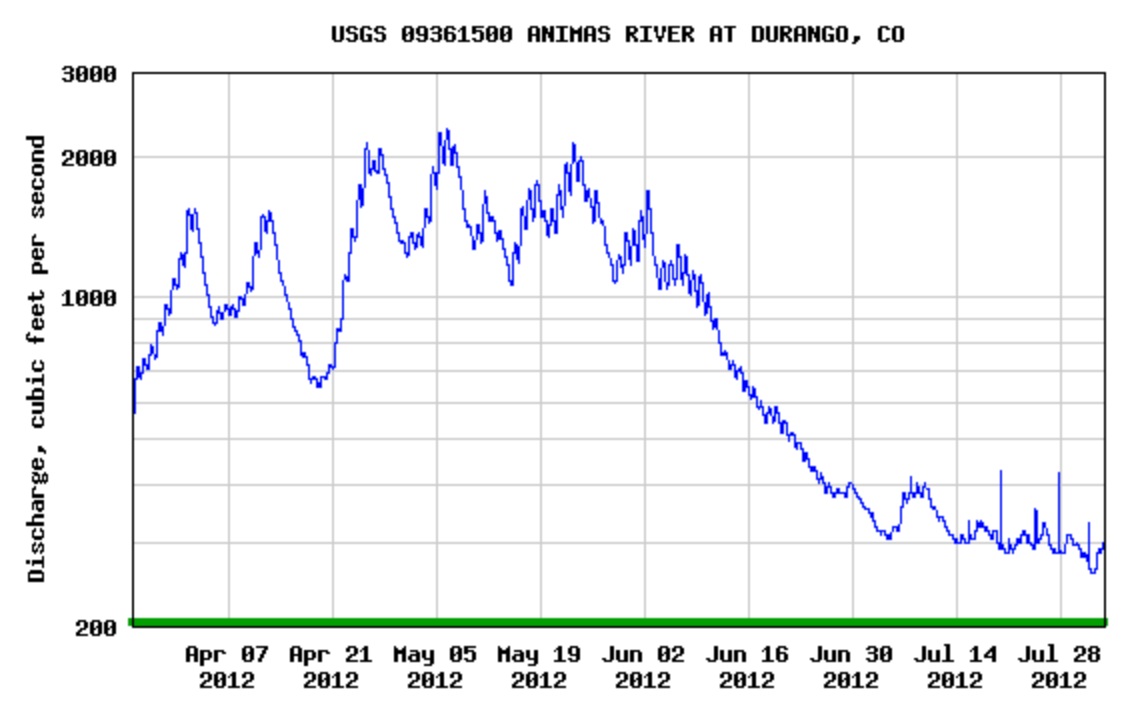
Still, a gander at the graphs here will reveal a bleak situation. I chose three high-altitude SNOTEL stations to track. Columbus Basin is in the La Plata Mountains, and is the farthest south, Red Mountain Pass is the northerly-most station, and Molas Lake is somewhere in between. The graphs show this year’s snowpack levels on the first day of each month, along with the average for the recording period (which varies by station), and the lowest five years on record. I also threw some other graphs in there, including Animas River flows for 2002 and 2012 (two of the driest years on record) to give some indication of what we might expect this year. It certainly looks like runoff could peak before June, and may not even exceed 1,000 cfs.


Screen Shot 2018-05-02 at 7.59.05 AM
After a slow start, the snowpack started to recover on Molas Pass in February and March, only to suffer through a late April melt that brought it down to 2002 levels.
Screen Shot 2018-05-01 at 5.20.37 PM
Snowpack levels on May 1 at the Molas Pass SNOTEL station are on a serious downward trend. This year’s levels are rivaled only by 2002, 2012 and 2013.

Screen Shot 2018-05-02 at 8.00.01 AM

Screen Shot 2018-05-02 at 7.48.15 AM

Screen Shot 2018-05-02 at 12.12.44 PM
2002 was the year of our discontent, weather-wise. The winter was weak, the spring was warm and dry, runoff on the Animas peaked in May at 900 cfs, which is about one-fourth of a decent spring flow, and the Missionary Ridge fire blazed through a good part of the summer.
Screen Shot 2018-05-02 at 12.56.39 PM
Judging by snowpack levels, this year’s spring runoff is likely to fall somewhere in between 2002’s and 2012’s, meaning it will probably peak in May at levels far below average.
Screen Shot 2018-05-02 at 12.14.17 PM
Is the Animas River already hitting peak spring runoff? It was looking that way, but then a winter storm slammed into the San Juans in early May, delivering a little bit of salvation, perhaps.
Screen Shot 2018-05-02 at 12.35.40 PM
The Animas River in Farmington nearly went dry in April (this is not due to a faulty gage — I witnessed the trickle on April 18). It would appear that one or more of the seven or so major diversions between the New Mexico state line and the confluence with the San Juan are responsible for the huge drop in flow beginning in mid-April.


Advertisement

2 Comments

Leave a Reply

Fill in your details below or click an icon to log in:

WordPress.com Logo

You are commenting using your WordPress.com account. Log Out /  Change )

Twitter picture

You are commenting using your Twitter account. Log Out /  Change )

Facebook photo

You are commenting using your Facebook account. Log Out /  Change )

Connecting to %s