
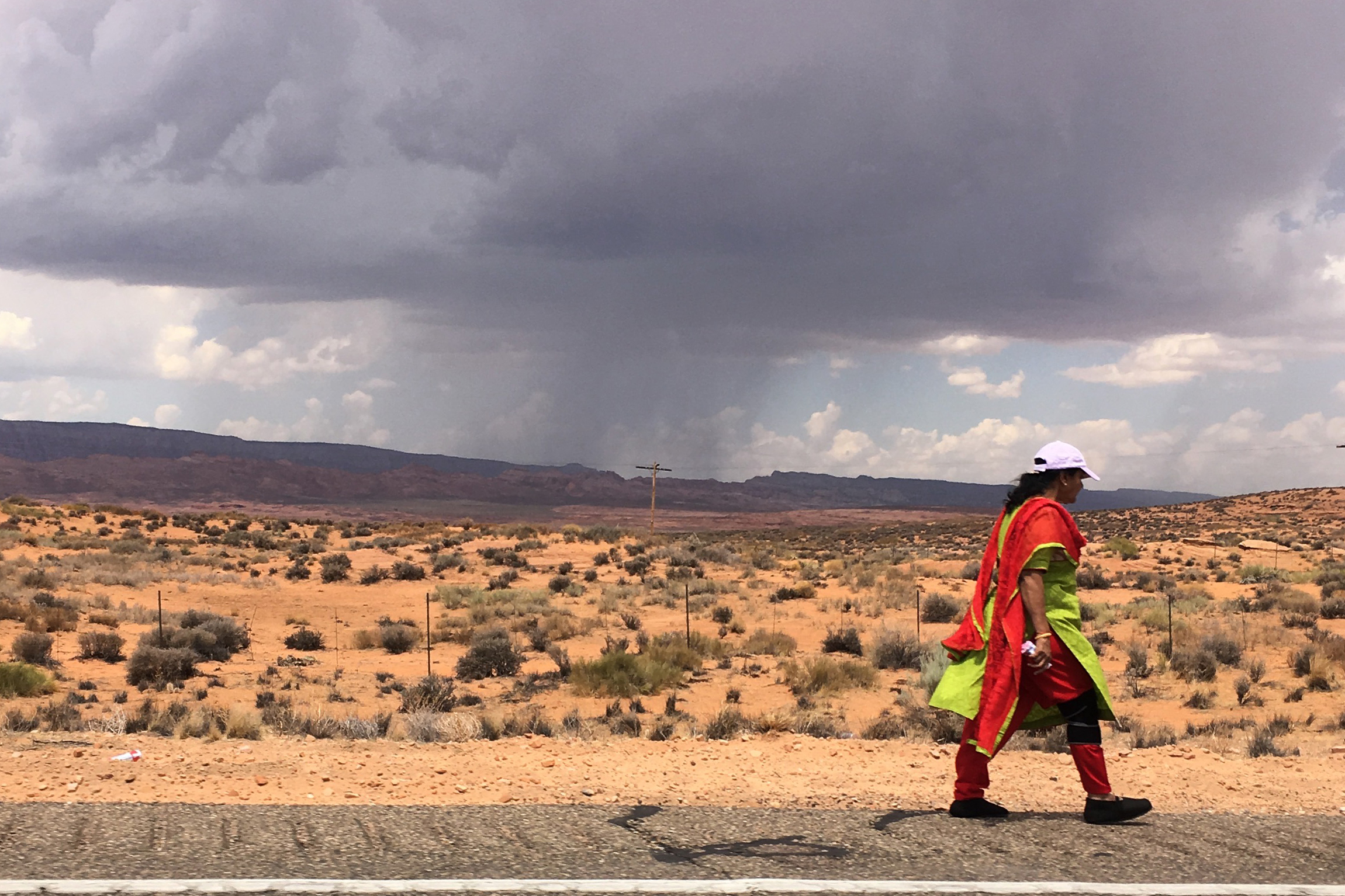
It must be a mirage, I thought, when I first glimpsed the flash of color in the distance. The little thermometer that hung from my rear-view mirror of my old car read 110 Fahrenheit. I had been driving across the northern Arizona desert for hours, all asphalt and dust and stone and searing sunlight. A heat-induced hallucination was not out of the question.
Yet she was real: A woman, dressed in a brilliant white ball-cap and a lime- and tangerine-colored sari that fluttered behind her in the wind. She tread purposefully along the side of the highway several paces behind a man who was probably her husband. Up ahead, another three dozen people, their attire less vibrant, walked toward a cluster of cars and flashing police lights, as if on a pilgrimage to a holy site.
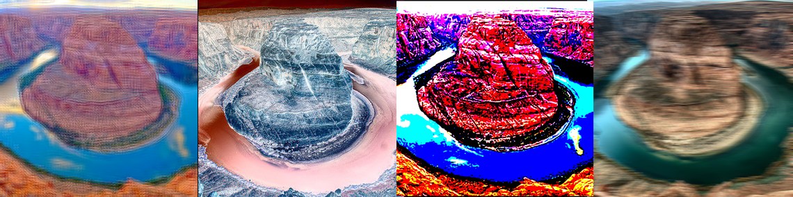
Like hundreds of others that day, they had disembarked from their air-conditioned tour buses and rental cars and risked heat stroke and dehydration in order to plod through the heat to see Horseshoe Bend, where the sandstone gorge of the Colorado River bows back on itself so as to create a nearly symmetrical image of deep green waters contained by desert-varnished cliffs. A police officer stood next to the highway, directing a steady stream of traffic in and out of the overflowing parking lot.
Horseshoe Bend has received a lot of attention lately, and not just from tourists. It has become emblematic of the growing number of places that have been “ruined” by social media, and a cautionary tale of the sort of industrial tourism that will befall previously “undiscovered” landscapes when they are designated national monuments or parks. But as I gaped at the tangle of humanity I wondered whether there wasn’t another lesson to be learned here, something less obvious. And as I rolled past without stopping I couldn’t help but feel a tinge of regret, a sense of missing out on something big.
***
Back in 1934, a young man named Everett Ruess wandered into a tributary canyon to the Escalante River, some 40 miles upstream from Horseshoe Bend, and vanished, never to be seen again. Ruess may very well have met a terrible end, but the mystery carries with it a romantic sheen nonetheless, a promise that even then, long after the industrialization and urbanization of the West was well under way, Ruess could still imagine himself to be the first white person to witness certain nooks and crannies of the region. There were still places where a human being could wander into oblivion.
Fifty years later, my dad, his friend and I went on a week-long mid-winter backpacking trip in a canyon not far from where Ruess was last seen. On the way in, we stopped at a dusty old store in Escalante and picked up cold pop, expired Fritos and a healthy dose of stink eye from the grizzled locals who had gathered there. After that, we saw no one, no cars on the road to where we started walking, and no other hikers after we embarked on our journey. As we walked down the chilly, sunless canyon bottom, and waded across the thigh-deep, ice-choked Escalante River, the possibility of pulling a Ruess seemed alive and well.
President Bill Clinton drew a line around that place and another 1.8 million acres of public land in 1996, and named it Grand Staircase-Escalante National Monument. The place is different, now. Something ineffable has been lost. The dusty little stores have been replaced by ones that carry organic produce, tofu and Ed Abbey books, the stink-eyed locals are now cogs in the service economy. Ruess would have a tough time losing himself these days among the one million or more visitors each year. Surely, however, he’d be able to leverage his canyoneering skills to become an adventure guide, a seller of solitude: You, too, can experience an all-inclusive vanishing act behind the Slickrock Curtain — for a price.
Winston Hurst, an archaeologist from Blanding and a descendant of some of the first white folks to venture into what is now known as Bears Ears country, talked about that phenomenon in 2016, when I chatted with him about the proposal to designate a national monument in his community’s back yard. National monuments and parks, he said, “feel like theme parks that have an artificial stasis imposed upon them. They feel dead. It’s the death of Place…. we’re not saving anything. Imposing monument status is like taking a corpse, painting its face with rouge and lipstick, and taking its picture for money.”
Visit Arches National Park on any day in May and you’ll understand what he meant. Wait in a line of traffic, breathing the exhaust of the idling vehicles of the other 7,000 visitors that day; drive along the asphalt ribbon that undulates through the stone and dirt; fight the hordes for a place to park in the viewing turnouts then give up and snap a picture from the comfort of your moving, air-conditioned car; jostle with crowds along the wide, obstacle-free trails. Head back to Moab and pay five bucks for a coffee and a front-row seat to watch the scene on the main drag — a steady stream of ennui-inflicted window-shoppers, bike-laden SUVs, helmet-cam-wearing adrenalin freaks, and the giant side-by-side ATVs that have become the latest rage. Listen to the roar of the combustion engine, the hum of rubber on slickrock, the fake-click of digital camera shutters. It’s an orgy of consumption: of experiences, petroleum products, and the spectacle of the wild. Ponder your trip through Arches. Gone is the solitude and illusion of discovery that earlier visitors must have felt. Gone the freedom to wander off the beaten path and meander aimlessly across the ocean of sandstone. In their place a circus-like gawk- and photo-snapping-fest.
When, in 2010, the Obama administration began toying with the idea of designating Cedar Mesa and vicinity in southeastern Utah a national monument, I shuddered. It had long been a place to which my parents — towing me along from an early age — made weekend pilgrimages. Here I have sought beauty, quiet, and solace: from teenage angst, the restlessness of my twenties, and midlife melancholy. Draw a boundary around a landscape, give it a national monument or park designation, and slap a name on it, and you’ve reduced something indescribable and wondrous to a brand, a slogan, a commodity to be marketed to the masses. Impose upon it a bunch of rules, entry fees, campgrounds, and designated trails, and you take away a freedom that is inherent to the place. I fretted about the loss of solitude and freedom to roam and camp where one wanted. Before you knew it, Bluff would be the next Moab; Moon House the next Horseshoe Bend; and Blanding would be overrun by overpriced brewpubs and chain-smoking French tourists.
My fears were warranted, but my line of thinking was flawed. It presumes that Moab is Moab because of its proximity to Arches, that Arches is so crowded because it’s a national park, and that Horseshoe Bend is the Desert Southwest’s equivalent to the Eiffel Tower because it’s in the Glen Canyon National Recreation Area. It presumes that national monument, park or Wilderness designation was the primary catalyst bringing people to these areas, and that such a designation is an automatic sentence for the place to be loved to death, as they say.
To test this presumption, consider the alternative. What if Arches had not been named a national monument back in 1929, and instead remained relatively unprotected federal land like most of the landscape around Moab? Would the spectacular stone formations have gone unnoticed, and remained “undiscovered” except by a handful of intrepid adventurers willing to wander into the non-national park wilderness? Would Moab have remained a busted uranium town like it was in the 1980s when mountain biking took hold? Unlikely.
Instead, the entire park would have been crisscrossed with roads beginning in the 1940s, when the uranium rush was on. It could have been mined for uranium and potash and drilled for oil and gas. Jeepers and motorcyclists would have used the roads to access the rock formations upon which they could play. Then, in the 1980s, the mountain bikers would have co-opted those trails as their own. Arches would have become just another part of the area’s recreationist amusement park, adrenalin junkies would be swinging from Delicate Arch, slacklining from fin to fin in Devil’s Garden, mountain biking, jeeping, and ATVing on a web of roads and trails through and maybe even across some of the arches.
Moab is not Moab because of nearby national parks, it is a recreational mecca because it is otherwise surrounded by spectacular, relatively unrestricted public lands where for years extractive industries and then motorcyclists, jeepers, rock-crawlers, mountain bikers, climbers, jumpers, runners, and hikers were allowed to dig and drill and drive and play virtually unfettered. When market forces busted both the uranium and oil and gas industries in the 1980s, locals desperately sought ways to fill the void, and recreation-driven tourism fit the bill. The proximity of a national park was just gravy. Moab became Moab in spite of Arches, not because of it. After all, most of the activities upon which the local economy relies are banned or highly regulated in the national park.
National park status for Arches, and to a lesser extent Canyonlands, may have imposed an “artificial stasis” on our experience of the landscape, as Hurst pointed out. Yet it also gives land managers more tools to keep the crowds from destroying that same landscape.
It’s a tradeoff, always a tradeoff.
***
 For years, Horseshoe Bend was little known except to locals from nearby Page, Arizona. Then, beginning in the last decade or so, the masses began converging on the place. More than one million people made the short, sandy hike to Horseshoe Bend last year, according to National Park Service statistics, and it appears that 2018 will be even busier, despite the extraordinary heat and drought. The slickrock pilgrims spoke French, German, Mandarin, Russian. They got into car crashes, performed marriage proposals, suffered from heat-related ailments, shot images of their feet dangling over the abyss. One died, and dozens had to be rescued by local emergency officials.
Horseshoe Bend has been a part of the Glen Canyon National Recreation Area for more than half a century, and the iconic image has appeared in magazines and marketing materials for nearly as long. Yet it wasn’t until after the first wave of Instagrammers arrived that things started getting out of hand. Images shot from the overlook — usually including someone either scantily clad, in a yoga pose, or both — began to proliferate on social media. That, in turn, brought more hopeful Instagrammers, selfie sticks and yoga pants in tow. The more #horseshoebend images show up on Twitter or Instagram, the more visitation increases. Rather than looking for that original shot, people seem to crave the copy, the replica image of the images they’ve seen most often on social media.
I’ve tried to understand this phenomenon to no avail. It is clear, however, that the popularity of the site has nothing to do with its land-use status. No one has really actively marketed the place as a destination, because there’s no good way to monetize it. And it was only during the last year that infrastructure — an actual parking lot, toilets, and an established viewpoint with railings — was put in as a reaction to the growing crowds.
After passing by Horseshoe Bend, I stopped at another newly constructed viewpoint that overlooks Glen Canyon Dam, that 10-million-ton wedge of concrete that holds back the waters of the Colorado River — a fine example of American brutalist architecture. The viewpoint was busy with folks speaking a variety of languages, yet far less crowded than Horseshoe Bend. The only overheard conversation I partially understood was that of a man explaining to his son, in German, the principles of hydropower. High-voltage power lines reached across the abyss like filament, electrons shivering within to keep the air conditioners in Phoenix cranking away. A thousand feet directly below the viewpoint, on a sandy stretch of beach on the cold and placid water of the down-dam river, a half-dozen people with rafts and paddleboards lounged, apparently unworried about some kid succumbing to the primal impulse to throw a rock over the edge.
Upstream, behind the dam, stood the stagnant, shrinking, silting waters of Lake Powell, a monument to our hubris, our insatiable urge to tame and to control the uncontrollable. A houseboat floated oddly near the structure. Maybe the captain was looking for the perfect photo-op, or perhaps Hayduke was at the wheel, trying to get within range.
A steady stream of cars and buses and RVs crossed slowly over the bridge in front of the dam. Emergency vehicles, sirens blaring, raced down to the water’s edge forebodingly. Downtown Page, a collection of wide streets and tourist-oriented strip malls, chain hotels and mid-century tract homes that emerged to give the dam builders a place to live, bustled, perhaps generating enough sales taxes to pay for all the emergency services that being a national playground entails.
***
 East of town, looking like an illustration of the false dichotomy of Old West versus New West, the trio of Navajo Generating Station smokestacks loomed over the Antelope Canyon parking lots, which bulged with cars and buses. The sinuous slot canyon is another victim of the Instagram phenomenon. The most expensive photograph ever sold was made here. It’s called “Phantom,” and its subject is a cloud of sand particles illuminated by a shaft of light from above. The photographer most likely was a participant on a guided tour, and was one of several taking the very same shot at the same time. The tour guides routinely toss sand into the shaft of light to create the desired effect. It’s worth noting that a previous holder of the most-expensive-photo record was Richard Prince, who photographed a Marlboro ad from a magazine, cropped it, printed it, and sold it for $1 million. Originality is dead.
Now the activewear-clad masses flock to the canyon, where a flash flood killed 11 people in 1997, to recreate the image, inserting themselves into the light beam while assuming various poses, making marriage proposals, sometimes even stripping off their clothes. The main part of the canyon lies within the Navajo Nation, so visitors have to pay a fee that goes to the tribal government as well as paying for a guided tour. That doesn’t seem to discourage anyone from crossing Antelope Canyon off their so-called bucket list.
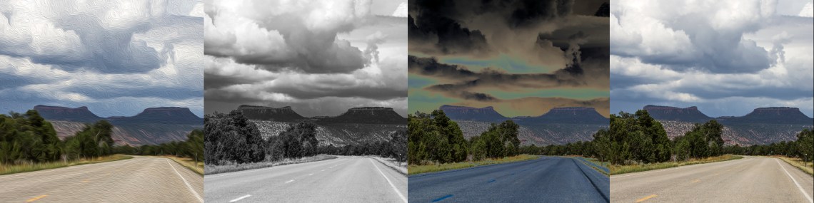
More driving, past the coal silo for the Black Mesa mines, alongside the ominous-looking  volcanic plug known as Agathla Peak, and toward the red rock spires of Monument Valley. Rain had fallen shortly before I arrived, but only enough to wet the dirt and add a smidgeon of humidity to the hot air. In the distance, a human seemed to stagger along the highway’s yellow line. Thinking it was an accident, I let off on the accelerator, braced myself for carnage, prepared to stop and jump out and help. But no, it was just someone angling for that iconic shot, the selfie with the ribbon of asphalt stretching off into the desert.
On to Bluff, the self-proclaimed gateway to the Bears Ears National Monument, the boundaries of which are still being contested in the courts. Surely Bluff would be overrun by tourists flocking to see the new national monument, shrunken or not. On that particular day, however, the town was quiet, almost eerily so. Just a couple cars sat in the lot of the Twin Rocks Cafe, and the town’s sole gas station was bereft of tourists, aside from a young French couple who seemed baffled by it all.
I must have been there on a slow day. Hotel rooms are at a premium in Bluff in the spring and fall, the hamlet’s about to get a new resort and spa, and the prices for the handful of properties for sale have reached the ridiculous zone. Bears Ears National Monument does not yet have a visitors center or entry point that would allow for a visitor count, so the best we can do is look at facilities nearby, such as Kane Gulch Ranger Station and Natural Bridges National Monument, both of which lie within the Obama boundaries of Bears Ears national monument, but outside the Trump-shrunken boundaries. Visitation at Bridges jumped by nearly 20 percent in 2016, while at Kane Gulch it climbed from 3,484 visits in 2013 to 6,535 in 2017. If San Juan County, Utah, was ever a “hidden gem,” as the marketing materials like to say, it isn’t anymore.
One could rage against the proponents of a Bears Ears National Monument for all of this, but to do so would be as misguided as it is futile. The visitor surge at Bridges and Kane Gulch coincided with the heating up of the debate over the monument, but it also mirrored similar increases at Arches, Zion, and Canyonlands, meaning it might just be spillover from Utah’s “Mighty 5” marketing campaign, launched in 2013 with a global reach. The economy also was recovering during that time, and the Instagram-era was blowing up as well. Most likely it was the collision of all of these factors that caused visitation to rise.
As far as Bluff goes, the seeds of gentrification were planted years before the monument effort hit the national stage, when many of the old stone houses built by the Hole-in-the-Rock settlers were converted to bed-and-breakfasts, when adventure guide outfits started to proliferate, and when the Dairy Cafe, which seemed straight out of a David Lynch movie, was supplanted by a “bistro” as the place to get a post-backpacking burger and a milkshake.
Likewise, it’s silly to think that the Cedar Mesa-Bears Ears-Comb Ridge area, or whatever you’d like to call it, was some sort of secret prior to the monument debate. That cat was let out of the bag years ago. Some of the main action in the Monkey Wrench Gang played out in San Juan County, and Ed Abbey fans have been trampling the slickrock and cryptobiotic soil here ever since. The internet has long been littered with detailed descriptions and coordinates of once obscure slot canyons, rock art panels, and even archaeological sites. It’s a quandary, yes: The rise in visitation and attendant effects begs for the heightened regulations and enforcement that a monument should bring, but the monument designation also may bring in more visitors. One can only hope that a well-thought-out management plan, crafted with input from the tribal nations that proposed the monument, will serve to offset the extra impacts. Under a Trump administration, that may be too much to hope for.
I left Bluff and headed east into the Aneth oil field, a place of spare beauty punctured by rusting pumpjacks grinding slowly into the earth. Oil companies have been sucking hydrocarbons from this ancient seabed for more than 60 years. That’s six decades of resource colonization, worker exploitation, leaky wells, busted pipelines, poisoned springs and corporate profit. In hopes of bleeding yet more carbon-emitting fossil fuels from the old wells, they shoot carbon dioxide — sucked from the McElmo Dome a couple dozen miles away — into the old wells. It is a strange world we live in.
At least, I thought as I listened to the wind and the chug-chug of the wells’ diesel engines, the Aneth oil field will never be loved to death.
I wonder about the term, “loved to death.” Seems like a good way to go, quite frankly. We throw it around so casually, yet rarely stop to think about its meaning. The people gaping at Horseshoe Bend don’t love the place any more than they love the Kardashians. The crowds certainly diminish the experience of the place for people like me, people who like to be alone with their sandstone and sage. And though the crowds have beat a wide path through the scrub to the overlook, and all those emissions from all those cars, mine included, is wreaking havoc with the planet, Horseshoe Bend isn’t going to die from all the attention, nor are the Bears Ears, Arches, Zion or the Grand Canyon. Regardless of how many pilgrims arrive, looking for something spiritual in this land of stone and sky, it will never be loved to death. Place is more resilient than that.
***
 A few weeks later I returned, this time heading into the so-called Shaash Jaa’ unit of the shrunken national monument. Monticello and Blanding were even more bereft of tourists than Bluff had been earlier that month. Bluff may be starting to sort of resemble a mini-Moab, as the doomsayers predicted, but Blanding and Monticello are safe from the amenities-seekers and probably always will be. You can’t even get a beer with your burger in Blanding, so how will the requisite brewpub survive?
I drove west on Highway 95, passing a billboard for a forlorn looking development promising the “best view of Bears Ears.” Given its location, I suspect the views of the White Mesa uranium mill aren’t bad, either. I turned off the asphalt and continued another dozen miles or so on gravel roads. I saw no other vehicles. My favorite campsite was free, as were all the others nearby. For the next 48 hours I had the place all to myself.
I suppose that will change, just as all things change. San Juan County, the same folks who fought tooth and nail against the monument, have launched a “Make It Monumental” marketing campaign, and it put up a big billboard directing visitors to UtahSolitude.com for instructions on how to enjoy the sights of Bears Ears. Now that the county’s leaders have succeeded in getting Trump to eviscerate the monument, they apparently want to make some cash off the thing. Cynicism runs rampant around here.
I dropped from my campsite into a nearby canyon, one of the loveliest I know. The caresses of wind and water have left curvy and colorful patterns in stone. Thigh-deep pools of cool, stagnant water give relief from the merciless sun. Stout-trunked ponderosas jut up from the center of the wash, wearing necklaces of driftwood and debris. Milkweed pods await the caterpillar that will morph into a monarch butterfly. A whisper of a breeze and the dull hum of pollinators swirling around the blooming beeweed.
I suppose I should be worried about losing this place to the masses, and even now I’d probably have a harder time finding solitude if I were to come when it wasn’t so damned hot. But this is no Horseshoe Bend or Antelope Canyon and never will be. There’s nothing iconic here, no spectacular backdrops for scantily-clad selfies that would go viral. The beauty here is quiet, subtle, invisible to those who don’t slow down and pay close attention. This is drive-through country for the Instagram crowd, mountain bikers, and BASE jumpers. For every Horseshoe Bend, Little Wild Horse Canyon, or Antelope Canyon, there are thousands of places like this one that go unnoticed, undesired, un-gawked at. Who slows down to notice the psychedelic textures of lichen? Who will wander shallow canyons in search of the monkey flower growing inexplicably from moist stone?
When I talked to Hurst back in 2016, he was opposed to a top-down national monument designation. There was the artifice of the whole thing, and the stasis it imposes. Plus it would provoke a nasty backlash, he said, that might result in even greater harm to the land here and even more political polarization. Maybe some of the more spectacular sites would be overrun by the hordes, a la Horseshoe Bend. He conceded, however, that in the current political climate in southeastern Utah, it might be the only road to go down. “The alternative,” noted Hurst hesitantly, “is to loose the dogs of war on their ATVS and let them have at it. That’s just as distasteful.”
But here in Southeastern Utah, unfettered ATVers and political polarization were already the status quo. The backlash was sparked years ago, when the feds first tried to hamper the pathological taking-disease that infected the white settlers as soon as they arrived, and was further stoked with the election of a black man as president. And as off-road vehicles morphed from functional tools to recreational playthings, they metastasized on this landscape where, apparently, the soft and fragile soil beckons. The Sagebrush Rebels fight for the “rights” of the ATVers as if their unfettered use was granted by God or the Constitution. Those who most vocally fear the invasion of the so-called wreckreation economy worry more about mountain bikes and trail runners than these motorized beasts, which are easily the most obnoxious and destructive weapon of the industrial tourism and recreation crowd.
 After climbing out of the canyon I happened upon one of the hundreds of little two-track roads that spiderweb much of Bears Ears National Monument. It is a road to nowhere, really, but nevertheless San Juan County claims it as an official right-of-way, and will illogically fight to keep it open. Its seeds were probably planted years ago by someone cutting wood or just looking for an unbeaten path on which to drive their jeep or ATV. And because “it was there,” subsequent motorized travelers just had to check it out. I suspect that few of them slow down enough to realize that the path slices right through an archaeological site, or that one section is so rich with artifacts that it seems to have been paved with potsherds and pieces of chert that had been worked hundreds of years earlier.
Will managers of the new national monument — either shrunken or restored to its original boundaries — shut down this road or send in enough rangers to keep the yahoos from tearing off across cultural sites or cryptobiotic soil? I honestly don’t know. But the odds for increased protection seem greater under a monument than absent one. It’s always a tradeoff.
I sat on a high point and huddled in the tiny puddle of shade cast by a small piñon tree, waiting for the long and scorching and lonesome day to come to an end. I was wrong about Everett Ruess. He would have no problem disappearing into one of the little canyons cut into the mesa across the way. Hell, he could probably sit right here, next to this little zen-garden-like assortment of flora growing in shallow soil on the slickrock, and never be seen again. This place remains, even in the Instagram era, a misanthrope’s dream. I lifted my phone up to make a photo of the vista, maybe even a selfie with the stone in the background. Then something nearby caught my eye: An old rusty muffler, slowly being swallowed by cryptobiotic soil. I turned my camera on that, instead.
In years to come I may have to share this place with more and more people. That’s too bad. But then, it was never mine — or anyone else’s — to share in the first place.
Jonathan Thompson is the author of River of Lost Souls: The Science, Politics, and Greed Behind the Gold King Mine Disaster. 2018, Torrey House Press. BUY THE BOOK.


C’mon, Jonathan, of course it’s the human experience of a particular place that gets ruined. I can’t believe you of all people have to be reminded of that!
“No one has really actively marketed the place as a destination, because there’s no good way to monetize it. “ Huh? You think the sari-clad woman didn’t pay? Believe me, commercial tour operations are indeed allowed within (and over) National Parks, Monuments, and Recreation Areas.
OK, land status does not by itself lead to industrial tourism? I think that’s missing what the opposing argument was. Land status changes don’t happen by themselves. They instead happen alongside economic and cultural changes in nearby human communities. As you pointed out, you can get ruinous tourism whether the land is “protected” or not. Yes, the old guard of San Juan County has inevitably cashed in on the tourism opportunity, and they didn’t need a national monument to do it. (But they’ve certainly benefitted from the all the hoopla.) And so no, Blanding and Monticello are not gonna be safe from Moabization.
The point is it’s the destruction of the old economics brought on by an influx of local people with no need to make money the old way that eventually leads to a tourism-based economy and the displacement of the people who cannot or will not change their economics. This is history in the making and it needs to be documented, regardless of one’s opinion on the “it would’ve happened anyway” argument.
My only solace is knowing it’ll all be ruined even for the newcomers as they someday get knocked out of bed by a low-flying scenic chopper on the 8am run.
LikeLike
Doug,
Thank you for reading, and for commenting. I do appreciate it.
Yes, the human experience of a place is, indeed, affected by crowds, or by paved roads, or visitors centers, or rules, and the like. I don’t think you need to remind me of that; the piece was pretty clear on that point. Clearly, though, the crowds actually *enhance* the experience for some humans, for better or worse. That was another point I was making.
You’re absolutely right, also, about the monetization of Horseshoe Bend. People do pay to take tours that stop at, among other places, Horseshoe Bend. And you can even pay $5 to take a shuttle to Horseshoe Bend from nearby so that you don’t have to try to fight to get into the main parking lot. But most of that happened as a result of Horseshoe Bend’s popularity, which resulted not from conventional marketing, but from digital word-of-mouth, i.e. social media. There’s a difference.
And then there’s this statement: “The point is it’s the destruction of the old economics brought on by an influx of local people with no need to make money the old way that eventually leads to a tourism-based economy and the displacement of the people who cannot or will not change their economics.” …. Do you really believe that? You’re saying, then, that 1. Mountain bikers killed the Moab uranium industry? 2. Skiers killed Telluride/Aspen/Crested Butte’s mining industry? 3. Silverton’s mining industry went belly-up in 1991 because… what? The narrow gauge train? 4. And are you saying that Navajo Generating Station is shutting down because of the Antelope Canyon crowds?
Obviously, none of that is true. The “old economics” faltered or perished not due to newcomers or even environmentalism, but due to much larger market forces. That created an economic vacuum into which the tourism/amenities economy oozed. Look for an upcoming essay focusing on this topic. You can also read my book, River of Lost Souls, for an in-depth examination of amenities economies and extraction economies, how they play off of one another and also compete with one another, and how they affect the local cultures.
Will Monticello and/or Blanding become “Moabized”? Perhaps. All the public hand-wringing about Monticello going that direction is certainly going to draw attention, so it could be a self-fulfilling prophecy. And, as housing prices climb out of reach in Moab, Monticello might attract some of the spillover. But for now Moab’s home prices, while unreasonably high, are still lower than other amenities-rich towns in the region (you can get into Moab’s market for at least $100k less than in Durango, my hometown, and Monticello’s prices are relatively cheap), and there’s still room on private land in Spanish Valley and beyond for more development closer to Moab to accommodate the hordes. Blanding, in my opinion, simply doesn’t have the right ingredients to go that way. If anything in the area’s going to become Moabized, my money’s on Bluff, but that’s partially up to the newly incorporated town’s new leaders.
And yes, it is history in the making, for sure. And yes, it absolutely needs to be documented. That’s why I wrote this essay, not to mention literally hundreds of thousands of other words I’ve written on this and similar topics.
Thanks again,
Jonathan P. Thompson
LikeLike
Jonathan, thanks, at least we’re getting somewhere, if only on this smaller point of the essay. Yes I agree that the land-status changes did not cause the death of the old economies. They instead formalized that death, and that’s still economically important. The newcomers need those land status changes for a reason: business finance. Making absolutely sure there won’t be pump jacks ruining their future customer’s view paves the way for investors large and small to make the financial commitment that draws a particular and preferred segment of the tourist market. So while the new regime may not have caused the economic downfall of the old, it has definitely had a hand in making sure it will never come back.
LikeLike